
by Dimitris Kostopoulos, Professor of Petrology, University of Athens
The beginning
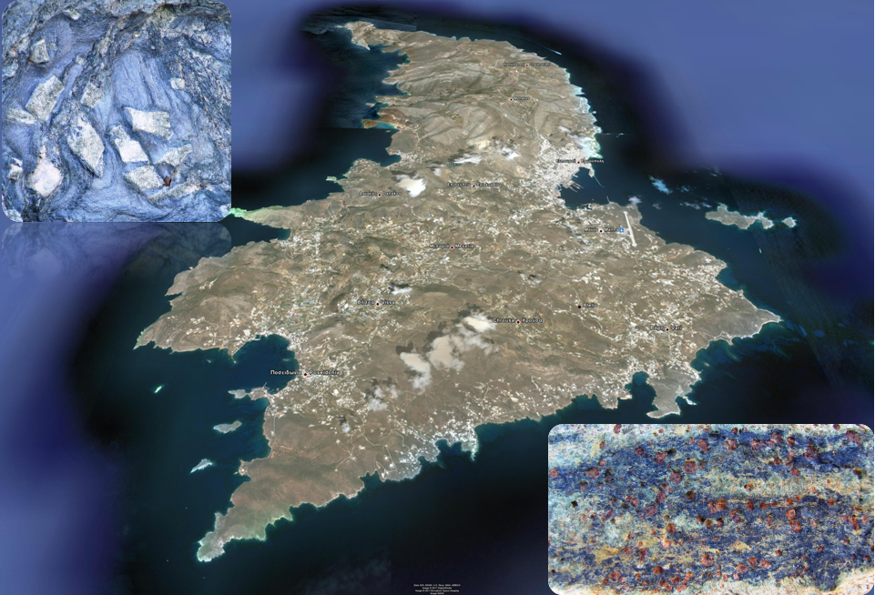
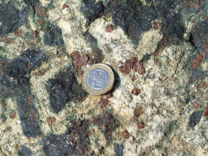
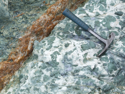
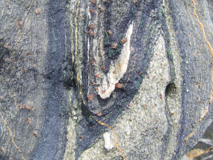
Approximately 170 years ago, in 1845, the German geologist Hausman discovered in Syros a mineral with a striking blue color that he called glaucophanis (from the glauca + phanis: it looks like blue). Since then, the cracked stones of the island, containing glaucophanis, have been called Cyan Schistoliths. Together with the cyanoschistoliths, some other rocks are found with minerals in deep red (granets) and emerald (omphakites) colors, called eclogites because of their selective, eclectic beauty. Both cyanoschistoliths and the eclogites were created in the midst of an ocean 80 million years ago, but they did not have the appearance they have today. This particular beauty in colors and minerals they acquired after they first traveled for 100 kilometers deep into the earth, they were transformed due to the high temperatures and pressure that existed there and, next, they emerged to the surface.
The “lady” of global geology
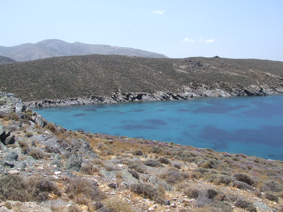
Nowadays Syros is considered to be the most representative site of cyanoschistoliths and eclogites in the world. The whole island is a geological museum, and it is rare to find a second, similar one. Every year, universities from every corner of the world organize geological educational trips to Syros, while the results of their studies are published in prestigious international scientific journals. Syros is a global geological heritage that we all have to maintain and highlight. We can do this better if we understand the importance it has for us, knowing where and how it was made and the journey it made to space and time.
Geological structure of Syros
Syros, as we know it today, has only been in the last ten million years. In fact it is a puzzle, whose pieces were created in different places, very distant from each other, and at different times, also very distant from each other. Each of these pieces had its own unique geological history and its own particular journey before, through the conjunctions of the geological evolution of the planet, eventually met and assembled. Let’s take the things from the beginning.
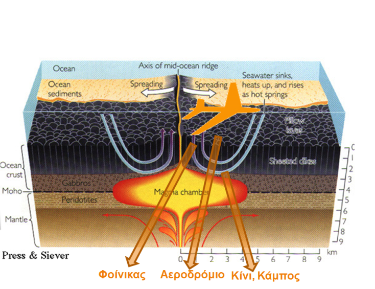
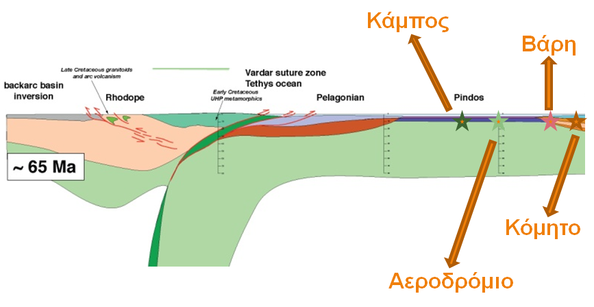
The puzzle of Syros has been synthesized from the rocks we encounter today, both on the continents and on the oceans of the Earth. The continental rocks include a background of (schistolithic) granites, which appear in the southern part of the island (Komito, Megas Gialos, Vari), covered with limestone and clay deposits (now marble and clay shale) that prevail in almost the rest of the island. These rocks were created on the edge of a continent over a 100 million year period! The rocks of the ocean shell, that is to say lava, spilled at the bottom of an ancient ocean, but also magmas that sank into chambers hidden beneath the bottom (now cyanoschistoliths and eclogites) are but a small percentage of the rocks on the island (Phoenix , airport, Kini, Kampos). If we go back in time, we would see, on a figure of a dissection of the oceanic shell, the airport and Phoenix on the ocean bottom, Kini 1-2 kilometers deeper and Apano Meria 2-3 kilometers even deeper.
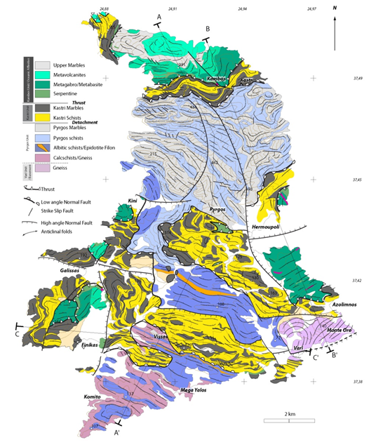
In the geological map of Syros, which we see below, the ocean rocks are depicted in shades of green, marbles in gray, schistoliths in shades of blue and yellow, while the granites are depicted in pink-purple colors.
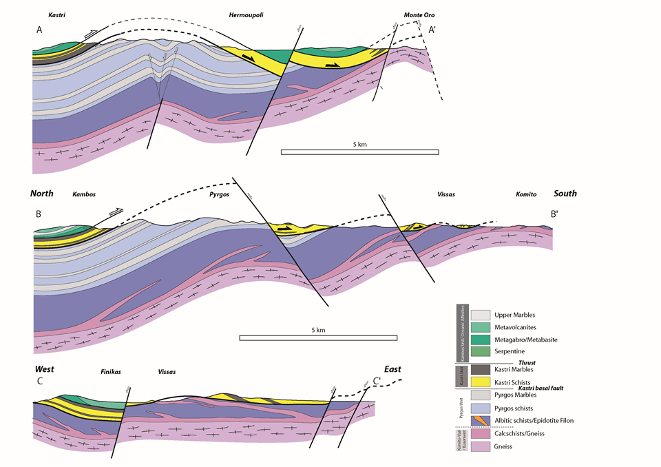
If we cut Syros vertically into slices following the lines A-A ‘, B-B’ and C-C ‘on the map, then in these sections we would see that, generally, the rocks plunge all over the island to the north. The lower rocks are the granites covered by the marbles and the clay shale. Segments of the ocean shell appear in the upper segments. Because of the inclination of the rocks, the granites only appear in the southern part of the island.
Trip to space-time
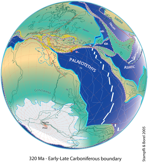
Three hundred twenty million years ago. Begining of the upper carboniferous period. As can be seen in the picture below, the land on the Earth consists of two major continents, Gondwana in the south and Lavrosia in the north, separated by an ocean called Paleotethys. This ocean sinks north below Lavrousia, just as the Pacific Ocean sinks under South America today. At the southern edge of Lavrosia, granites, such as those appearing in the southwestern part of Syros, are beginning to form around Komito (a brown star in the image). Above these granites, sediments slowly began to deposit, such as limestones and clays. The sea that existed between Lorraine and South America began to close.
We were then at 23° south latitude, in the Tropic of Capricorn where Brazil or Namibia is today, while southern India was in the South Pole. Over 40 million years ago, the continents are all united on a large land called Pangea. The Atlantic Ocean is not yet born, nor the ocean of Syros’s puzzles. India is still stuck with South Africa and Antarctica and is covered with ice.
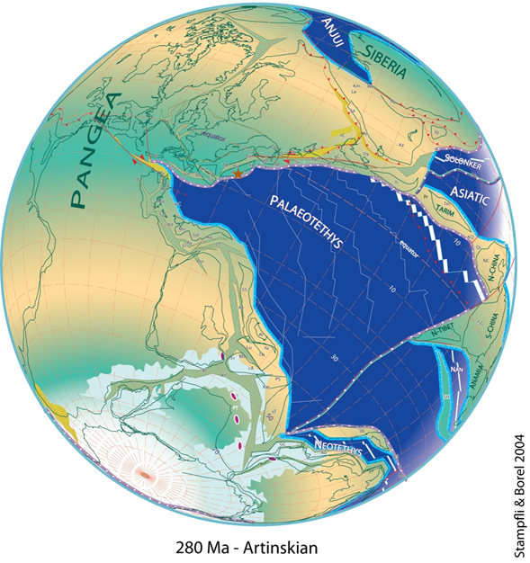
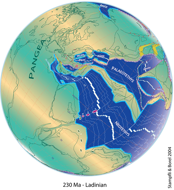
Another fifty million years passed. We are 230 million years ago, in the geological period known as the Ladino. The enormous ocean of Paleotethys, south of Komito, has been confined to a small sea, while new sea passages have been opened as the margins of Pangea are torn both to the north and to the south. The southern and western Greece (Peloponnese, Epirus) and the Taurus mountain range in Turkey, which once constituted the northeastern part of Africa, begin to peel off and travel to the north as the ocean of Neotethys opens. The margin of southeastern Europe that contained the region of Komito has been unpacked as it opens two other small oceans, Maliakos and Melita. The continental segment that contained the southwestern Syros begins to tear and this creates the south-eastern Syros – the Vari’s granite (pink asterisk on the map). We are now 15° or else 1700 kilometers north of equator. It’s been 90 million years since the Southwest Syros, which has already made a 4,300-kilometer trip, was first created!
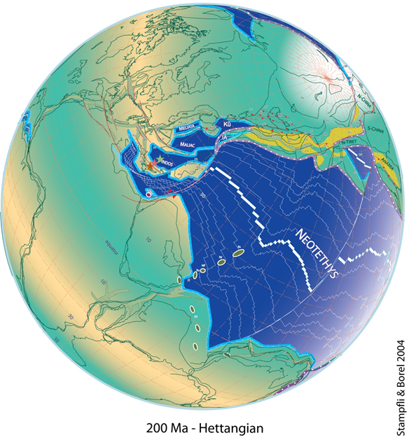
It will take another 10 million years to completely close the ocean of Paleotethys in the Greek space and to open the ocean of Pindos, in which the ocean rocks of Syros (green asterisk on the map) will be born. At the same time, the current Atlantic Ocean is beginning to open. But to create the ocean rocks that we see on the island today, it takes another 140-150 million years until we reach the famous Cretaceous period, when the great dinosaurs dominated the Earth. We are 80-70 million years ago.
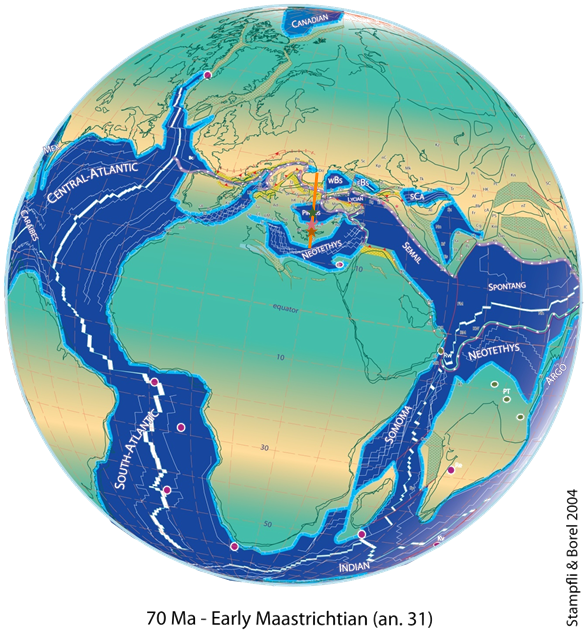
If we cut the Earth vertically along the orange line shown in the previous map, we would see the Greek lithospheric plaque, that carries on its back the ocean of Pindos, and southern Syros to collides with the South European continental plate and sink under it, where Rhodope is located. The pieces of the Syros puzzle are now close enough to one another, but not together. We are at the end of the Mesozoic age and at the dawn of the Kenozoic, 65 million years ago.
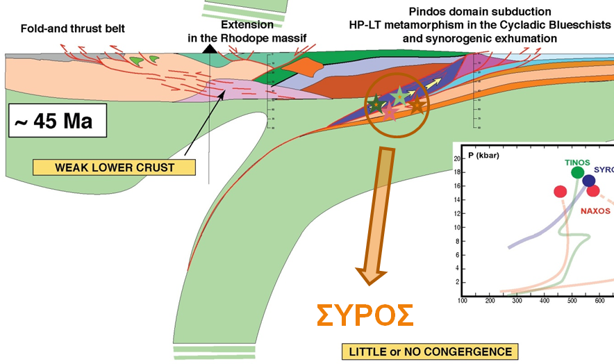
After 5 million years, the ocean of Pindos and the continental margin of Komito and Vari reached the point of collision of the two plaques and began to submerge within the Earth, reaching a depth of about 100 kilometers approximately 52 million years ago. It is then that, for the first time, the pieces of the puzzles are assembled together. After over 7 million more years, the unified now Syros begins the journey of return to the surface of the Earth, 45 million years ago.
But there will be another 30 million years before Syros begins to approach the surface of the Earth.
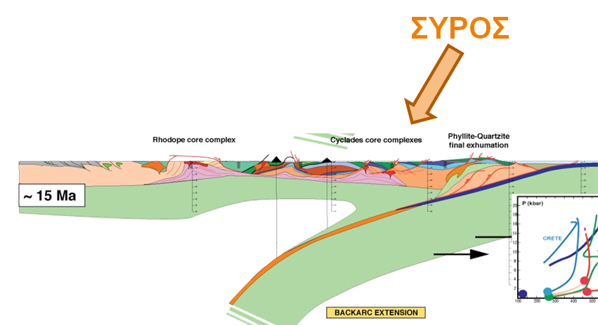
We are 10 million years ago, towards the end of the so-called Miocene period. The ‘lady of the Cyclades’ lies on the surface of the Earth almost in the form we know it today. It was not always an island. From that time it will be subjected many times to the advance and retreat of the sea, upward and downward movements of the earth’s shell and will be permanently at the mercy of weather, disintegration and erosion. The final result of geological developments that lasted 230 million years is in our hands. Let’s save it and let’s show it!
Τranslated by Constantine Hatziadoniu