Archaeology
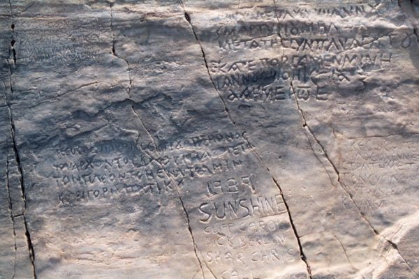
Syros has been a crossroads of people and cultures moving around the Cycladic archipelago since ancient times, as the references in the Odyssey suggest. The most important and best known archaeological sites of Syros are gathered in Apano Meria: such as the Early Cycladic cemeteries of Halandriani and St. Lucas, the settlement of Kastri and of course the cave of Ferekydis and the Grammata with their inscriptions dating back to the Hellenistic and Byzantine periods.
Saint Lucas with the early Cycladic cemetery.
Translated by: Aleka Ageletaki
Human presence in the Cycladic archipelago: a brief overview
31 July 2016
The islands of the Cyclades, because of their position and their historical significance, mark the dawn of Greek culture. The particularly favourable conditions of the Aegean sea, the climate, the open horizons and the possibilities of communication between the islands gradually changed the mentality of the first settlers, who shifted from being shepherds and farmers to sailors and workers, merchants and artists. Ancient writers like Herodotus, Thucydides, Strabo and Kallimachos used the name ‘Cyclades’ to describe the islands which formed a circle around the holy island of Greek antiquity, Delos (Ortygia in Homer). According to tradition Carians, Lelegians and Phoenicians were the first inhabitants of the Cyclades. The oldest habitation in the Cyclades goes back to 9000 BC as is shown by the remnants of a Mesolithic settlement with ruins of houses and open-air tombs, which was discovered in the area of Maroulas on Kythnos.
The obsidian from Milos found in the cave of Fragthi at Ermioni in the eastern Peloponnese proves the organised presence of man in the Cyclades by 8000 BC.
The settlement found on Saliago, a small island between Paros and Antiparos, is a rare example of civilization on the islands during the last part of the Neolithic Age (4300 – 3900 BC) and it has produced valuable finds.
On Andros there is a settlement from 4000 BC on the plateau of Strofila. It is the biggest Neolithic settlement in the Aegean and has the oldest rock paintings in Greece.
From the end of the 4th millennium BC and during the 3rd, parallel to the Early Minoan Civilizations in Crete and the Early Greek civilisation on the mainland, a civilization with specific features flourished in Cyclades starting in Kea ( at the settlement of Kefala 3300 – 3200 BC ). It is known as the Cycladic civilization and it has left unique artistic artefacts to posterity, most distinguished of which are the Cycladic statuettes. This civilisation developed in small independent settlements based on the sea. The islands might not have land to grow plants on, but they were at the crossroads of the seaways between Asia Minor, Greece and Crete. Cycladic ships sailed the seas, making contact with the areas around the Aegean, and exchanging products and cultural ideas. The Cycladic civilisation, which covers the years of the Copper Age (3200 – 1100 BC) is divided into three periods:
- Early Cycladic period (3200 – 2000)
- Middle Cycladic period (2000 – 1650)
- Late Cycladic period (1650 – 1100)
Source: Badisches Landesmuseum Karlsruhe / model construction: Bernhard Steinman 2011
During the first part of the Early Cycladic period houses were built on hills so that they were protected from floods and enemies. They were built far from each other without fortresses. The inhabitants were either fishermen or pirates. During the second part of this period Minoan Crete fought back against Cycladic pirate invasions. The people of the Cyclades lost control of the sea and were obliged to retreat into their heartlands where they built on hills protected by defensive walls. Houses were built very close to each other with narrow passages between them (Kastri and Halandriani on Syros, Agios Andreas on Sifnos, Panormos on Naxos, and Delos). During the 3rd period Cretan dominion is obvious. Almost all the settlements, except the ones on big islands with rich countryside, were again made by the seaside without walls around them (Melos, Paros, Amorgos, Thera). They were used as harbours for Cretan commerce.
Cycladic houses were small (with one or two rooms) and without a fireplace. Their roofs were light, made of branches, reeds and flattened clay. The design of the houses was adapted to the available space. As a result they were sometimes in straight lines and sometimes in curved ones. Defensive walls were built around each group of houses. Cemeteries were located on nearby slopes.
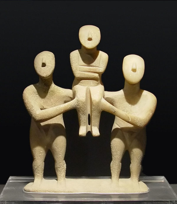
The people of the Cyclades did not produce monumental art. Their artistic activities are mainly shown in the large number of small pieces of art found in their settlements and their cemeteries (funeral gifts): for example, pottery in the shape of frying pans, which are still being investigated as to their use (Halandriani on Syros island) and pottery in the shape of sauce-boats or animals, as well as marbleware. They excelled in metal art and miniature art (tools, silver brooches, diadems, necklaces). The finest creations of the Early Cycladic civilization are the wonderful marble statuettes which had continuous production during the 3rd millennium BC. Naïve and schematic at the beginning, they progressed steadily to exquisite imitative pieces of art with detailed features on the body or the face. Most of them represent females, sometimes in pregnancy, two dimensional and frontal. Later, when the artists were certain of the material they were working on and could make three-dimensional pieces, they constructed complex and amazing sculptures like the famous creations “The Harp-player” and the “ The Flute-player”, which were found on Keros and have become symbols of the Early Cycladic period.
During the next period of the Cycladic civilization, the Middle Cycladic period (2000-1650 BC), the Cyclades were still influenced by Minoan naval supremacy. This strong influence is quite obvious in Thera, where multi-storey houses were built and decorated with exquisite wall paintings (Akrotiri ). Settlements are still being built by the seaside ( Melos-Filakopi II, Paros-Parikia, Kea- Agia Eirini, Thira, Thirasia, Delos, Tenos, Syros, Sifnos, Amorgos), promoting commerce between Crete and the other parts of Greece. This period, having produced many valuable artistic creations, was interrupted violently by the destructive explosion of the volcano on Thera about 1650 BC.
During the Late Cycladic period (1650-1100 BC) we have the sudden disappearance of the Minoan civilization (at the end of the 16th century), most possibly as a side effect of the explosion of the volcano on Thira. As a result Mycenaean domination followed that of the Minoans. The first Mycenaean centres of trade appeared before the end of the 15th century.
By the beginning of the 14th century they had spread to Naxos, Delos, Kythnos, Serifos and Melos (Filakopi III). Three centuries later the decline of the Mycenaean world was felt in the Cyclades as well and soon after 1100 BC the last Mycenaean strongholds were abandoned .
The Cycladic civilization started being studied in the last decades of the 19th century mainly due to the archaeologist C.Tsountas, who excavated many Cycladic cemeteries in Syros, Paros, Antiparos and Sifnos.
Translation: Erene Drakou / Edited by Rupert Smith
First signs of human presenceσίας
24 August 2016
by François Aron
The French archaeologist, François Aron, traveled to Syros in the 1980s and, by doing surface research, attempted, on the basis of archaeological finds, to locate prehistoric habitation places on the island. The findings of his research were published in 1995 in Syros Letters, Vol. 30, from where we report here the findings related to Apano Meria.
Chalara
People settled west of the spring of Syringa, in a landscape with more fragmentation than other Early Cycladic sites in Syros. A thick marble layer was cracked and torn into slabs, sometimes suspended between boulders of all sizes. The exploration of the caves and the rocks did not work: the settlement did not start, as is sometimes the case with the rocky shelters, before settling in the countryside, although these parts may have been used as storage areas or pens. We find traces of habitation on the steps between the rocks—sometimes near the entrance to the caves—but also on the platforms, the hollows and especially on the flat surfaces, surrounded by natural cracks. On one of the flats, 150 square meters in size. and a slope of about 15°, many remains were found, as well as schistolith plates probably used in constructions. Buildings also consisted of small volumes of marble, but there are no clear traces of walls. The conical cores and arrowheads with stem and hooks that were found are of Neolithic type, and only the spikes are formed by overlapping treatment. An opaque, scraper with flakes and blades and one scraper of flint are the only tools that are formed by peripheral processing, but they also must have used the blades as unprocessed tools. Ceramic art is limited and is kept in poor condition. As for the construction, it looks like that from Chontra of Vari, (where the polished surface of the vessels has a beautiful brown, glossy color, but no written shell was found.) The most common shape of the bottle is the conical, the hemispherical ones are rarer, and in the Chontra we see large utensils with strap handles is however better cooked and granular (sic). A ring-shaped bottle, 1 hemispherical, 1 with a leg, and other ones with vertical walls were found. The relative abundance of closed vessels may be related to a specific function of position (dairies vessels?). This site, modern, earlier or later than the Chontra, has particular cultural features, which suggests that the settlement of Syros at the end of the Neolithic period took place by different groups, perhaps even living in the same place. However, we cannot rule out the assumption that the 10 sites found in Syros belong to the same culture, but they are not modern and some of them were pens or stables.
The immediate natural environment of Chalara has similarities with the Atziganokastro of Syros, but spreads to a greater extent, in a much more scarp area. Perhaps the different groups of people, depending on their size, had been settled in isolated and naturally protected areas. Their bonds were probably weaker and the total number smaller, since the areas that seem to have been inhabited, account for only 10-30 dwelling units, according to our calculations.
From Chalara we enjoy the open view to the northern part of the island and to the sea, at a distance of 20 minutes of the hour, a distance that ensured the safety of the settlement, but also allowed part of their food to be fished (some sea shells were found). The inhabitants must also practice the livestock farming (some caves are still nowadays used as pens), use the water from the Syringas spring and have the supervision of the pastures and perhaps the fields in the northern part of the island. In the immediate area of Chalara, there are 2-3 hectares of arable land, and perhaps in the surrounding ridges the soil was not completely swept away by the erosion.
Akra (Quarry)
A small settlement is found on the western slope of Akra, above the bay of Dolphin, on a flat fold of marble below the quarry. Ceramics, without being particularly diagnostic, must belong to the Early Cycladic II. The stonework includes blades and trimmers with parallel sides and a considerable number of processed tools, which may mean a relatively early site dating (beginning of the period).
San Michael
The shells that were collected on the village’s location date back to the 2nd millennium, mainly during the Greek-Roman era. Some ambiguous shells and perhaps one bottle shell with an internally bulging lip could be dated to the beginning of the Early Cycladic. There are no obsidian, only 1 scraper from a flint, maybe the 2nd millennium. On the sides of the Mavrovolades, 400 meters east of the site, the clay of one shell reminds the end of the Neolithic or the beginning of the Early Bronze Age. If this is true, it may have been transported there during the fertilization of the fields, but nothing can indicate when the shell was transferred.
Pyrgos (Plateau)
From a marble protrusion on the western edge of the plateau, which extends to the west of the highest point of Syros, there is a small collection of obsidian with a high frequency of processed tools and pointed arrows with staff and fins, but the processing is less thoughtful than that in Chontra. The pottery is scarce, we note 1 spherical bottle. There is still a small arable land at the edge of the plateau, from where a narrow valley begins, but the location, probably a very small village, seems more suitable for livestock farming.
Translated by Constantine Hatziadoniu
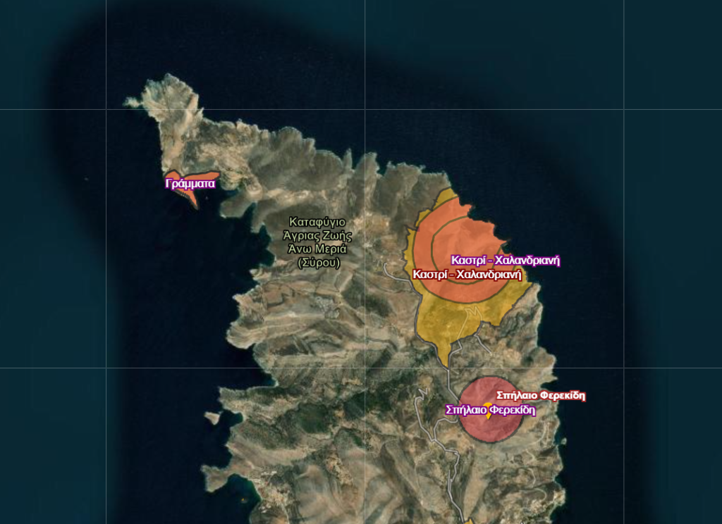
The archaeological site of Chalandriani – Kastri
24 August 2016
by Marisa Marthari
Sites and their Dating
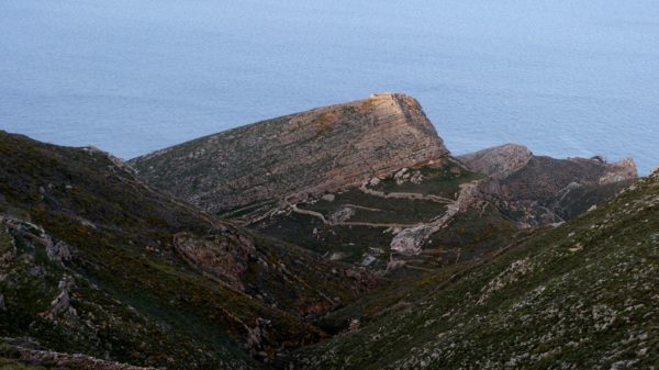
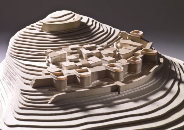
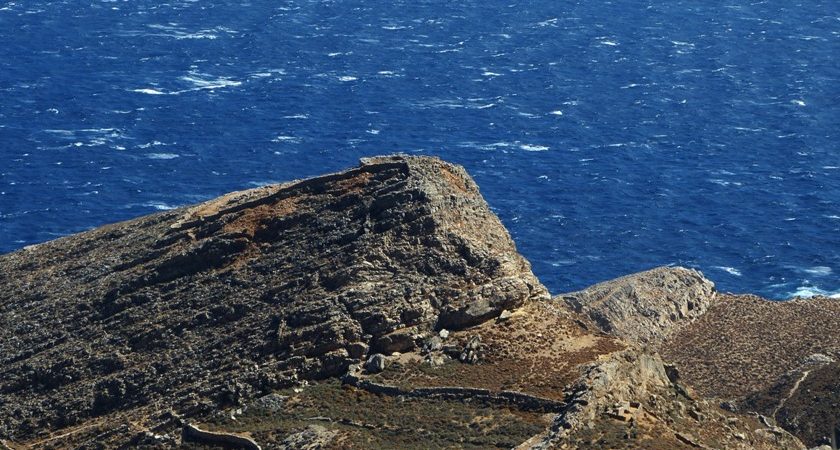
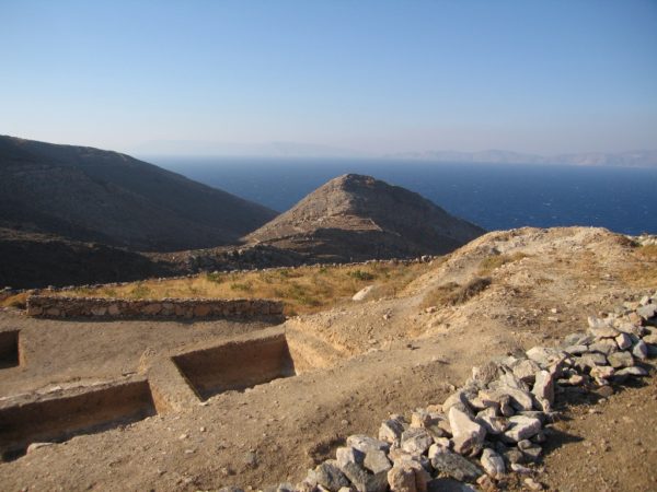
Chalandriani and Kastri are located on the northeastern coast of the mountainous North Syros or Apano Meria. They look towards Tinos and Andros. Chalandra is the name of a small fertile plateau extending to the sea through two rocky slopes. At its highest point in the south there is a small church of Panagia [Virgin Mary] of Chalandriani. To the west of the Chalandra Plateau is the steep hill Kastri whose top rock is marble. The two are separated by the deep ravine of Potamia, which ends at Cleisoura Bay. At some places there, there is springing water throughout the year. The excavations that took place in the area during the past and present centuries brought to light the fortified settlement of Kastri, located at the top of the hill that goes by the same name, and the extensive cemetery of Chalandriani, where the rows of its graves once stretched across the plateau of Chalandra, in the northeast of the modern settlement of Chalandriani, and reached to the sea.
The fortified settlement dates back to the Kastri phase (about 2,300-2,200 BC). The cemetery includes mainly tombs of the Early Cycladic period (Keros-Syros phase, approximately 2,700-2,400 / 2,300 BC) and only a few that are contemporary to the Kastri settlement. Also, in the area, there is a second prehistoric settlement, the settlement of Chalandriani, that spreads around the church of Virgin Mary of Chalandriani and has been identified since the last century but has not been systematically investigated. It has been assumed that the Early Cycladic period tombs belonged to the settlement of Chalandriani, which would have been already inhabited since that period.
In any case, these two settlements of Kastri and Chalandriani must have occupied an important place in the settlement model of Syros corresponding to the Early Bronze Age. They were at a key point in the communication network that connected Mainland Greece with the Asia Minor coast: the Asia Minor coastal zone was then closer to the core of the civilized world than the central and western Aegean. This should have been one of the reasons for their particular development.
The exact settlement model of Syros in the Early Bronze Age is not yet fully known. Further systematic investigations are required, although in the last few years superficial investigations and pilot excavations by the 11thEphorate of Prehistoric and Classical Antiquities at certain locations (Galissas, Delfini) have shown that Syros had a fairly complex grid of settlements, as is the case in other Cycladic islands. A first idea of the dispersion of sites in the Early Bronze Age is depicted in the map produced by Aron, which is based on earlier research but also on his many years of sightseeing in Syros.
HISTORY OF THE INVESTIGATIONS
Until now, the [archaeological] research in the area of Kastri-Chalandriani has gone through three phases.
The first phase is placed in the second half of the previous century. The explorations started from the cemetery. G. Papadopoulos was the first to excavate there in 1861 (Papadopoulos 1862, 1865) followed a decade later, in 1872-73, by the Syriot anthropologist Kl. Stefanos. In 1896, R.C. Bosanquet, a passerby from Syros, also investigated a tomb (Bosanquet 1895-96). Systematic excavations were carried out at the Chalandriani cemetery in 1898 by Chr. Tsountas, who investigated 540 tombs. The same year, Tsountas also excavated the walled settlement of Kastri, which he called the acropolis of Chalandriani. The excavations brought to light the front wall and the northern wall as well as a small part of the settlement, mainly the buildings that are adjacent to the wall. Tsountas presented the results of his excavations in the Cyclades in his two major articles in the Archaeological Journal of 1898 and 1899 (Tsountas 1898, 1899). In the second of these, he refers extensively to the results of his research in Syros.
More than 70 years later, in the 1960s, and in particular in 1962, there was a second phase of research activity in the region. Caskey visits Chalandriani and Kastri and makes interesting observations (Caskey 1964). E.M. Bosserr continues the excavation at the Kastri settlement. The new excavation confirms the existence of a western wall and reveals a larger part of the settlement to the top of the hill (Bosserr 1967). The then Chief Curator of Antiquities of Cyclades Chr. Doumas excavates 8 tombs in the western part of the Chalandriani cemetery (Doumas 1977, 128-130) and the then Ephorate of Cyclades N. Zafeiropoulos with the assistant of E. Kakavogianni, two other tombs. In the 1990s, a third phase of research began in Chalandriani. Hekman conducts a superficial survey in the area of the cemetery in 1989 and discovers the remains of some tombs that were previously excavated (Hekman 1991, 1996). Since 1990, the 11thEphorate of Antiquities has strengthened the area’s protection regime (see below, p. 32) encouraging the resurgence of the research. In the area of the modern settlement of Chalandriani, the exploration of the subsoil begins with trial sections, where there is an interest to build and monitor the dry-stone walls which are demolished in order to collect the prehistoric material that is embedded in them. The results of the surveys so far confirm the view that under the modern settlement there is an early Cycladic settlement. The maintenance of the material of Kastri and Chalandriani begun since 1993—and continues—and it is kept in the Museum of Syros and is valuable for the research.
THE CEMETERY OF CHALANDRIANI
This cemetery is the most extensive early Cycladic cemetery that has been investigated so far. More than 600 tombs have been excavated (Papadopoulos 1862, 1865; Tsountas 1899, 78-116; Doumas 1977 in general and especially 128-130). The cemetery includes two sections, West and East (see also Renfrew 1972, 373-375, 528-531; Hekman 1991, 1996). The graves are arranged in clusters in each section. Sections and clusters probably reflect different social groups. Also, the variety in the number and type of grave goods (funerary offerings)suggest differences in the social status of the dead. Generally, the structures of the community or communities served by the vast necropolis at least during the Early Cycladic period seems to be quite complex. The tombs are dug underground and have a polygonal, circular or mixed plan. Their walls are built with overlaid stones without bonding mortar, in the freestanding way. The aperture in the center of the pseudo-dome is covered with a sizeable top plate. The entrance often has a threshold and pilasters of upright slabs and is blocked with a slab or dry-stone wall. In some, there is a simple path way in front of the entrance. This type of tombs is only found in Syros.
There are some known facts related to the burial customs. They placed the dead in the fetal position in the tomb without covering with soil. A stone plate was often placed beneath the head like a headrest. The grave goods were placed either on the floor of the tomb, usually in front of the deceased’s face, or in a niche on the wall.
Grave goods varied. The ceramic art is very interesting. The completely undecorated ceramic jugs and conical cups dominate in number. However, there are also two impressive categories of vases that are represented in the goods, the inscribed and the polished ones. Special mention is to be made of the clay pan-shaped vessels of the settlement with the elaborate printed and engraved decoration that belong to the polished category. Most of these vessels depicting rowing boats were found in the Chalandriani cemetery, which leads the researchers to consider the cemetery settlement one of the most important of the Early Bronze Age in the Cyclades (Brookbank 1989).
There are enough marble vases especially bottles, simple or tall ones. On the contrary, marble figurines are rare, mainly anthropomorphic in shape, of the variety of dokathismata. Rectangular panels and grinders of various types, as well as obsidian blades, belong to the typical grave goods.
Metal objects abound: needles, hole punchers, tweezers, scrapers. Fishing hooks are rare. There were also several silver, bronze and bone pins with elaborate heads; they were a part of the deceased’s clothing for the attachment of the garments.
An interesting type of finding is the bone paint-storing vases, many of which store cyan color paint. Red lumps were found in three tombs. It has been assumed that these colors were used to color the face and body. Jewelry was rare, as were the clay spindles.
Finally, food remains (goat bones, sea shells) were found in some bottles and cups.
THE SETTLEMENT OF CHALANDRIANI
The [ancient] settlement of Chalandriani lies under the modern settlement by the same name. The first to locate it was Tsountas, who even carried out a trial excavation and found remnants of walls. Tsountas believed this to be a very important settlement. Other important researchers of the Cycladic prehistory after Tsountas considered it to be the main settlement of the area (Tsountas 1899,78, 106-107, 127-130; Caskey 1964, 64; Renfrew 1972, 176). So far only Hekman has offered a contrary view (1991, 20, 31, note 2, 1996, 52, 72).
The investigations carried out there by the 11thEphorate of Antiquities in recent years confirm and reinforce the view that the settlement of Chalandriani lies under the modern settlement that goes by the same name. The Early Cycladic settlement seems to have been a large one for the Cyclades of the 3rd millennium, with an area of probably more than 10 ha. It is a settlement of the size of Scarcos of Ios and of Agia Irini of Kea, if not larger. Walls were recovered and moveable findings were gathered. However, further research is needed to establish the settlement time frame with certainty.
THE SETTLEMENT OF KASTRI
The settlement of Kastri (Tsountas 1899, 116-130 Bosserr 1967) is surrounded by a wall to the north, west and probably to the east but not to the south, where it is naturally fortified. Its total area is estimated at 5 ha. The wall consists of the front wall and the main innerwall with horseshoe-shaped towers. Both are built of large carved marble blocks without connecting clay except from some portions of the towers. The marble must have been quarried on the site.
The front wall extends only along the northern slope, which is the most accessible from the sea. It consists of two long arched sections. The east part is slightly farther south of the west part so that about a 0.60-meter wide gate is created between them. The main wall consists of a north long section, a shorter west section and perhaps an east section in proportion to the west one, as Bossen assumes, although no traces of it were found. The northern wall is reinforced with five horseshoe-shaped towers. The remains of only one tower are preserved in the western wall.
The entrance to the settlement was possible from both the north and the west. Those who wanted to enter from the north had to first cross the gate of the front wall and then enter the settlement through the central gate of the tower B or the gate to the west of the tower C. For those coming from the west, the entrance was through the gate to the south of tower Z.
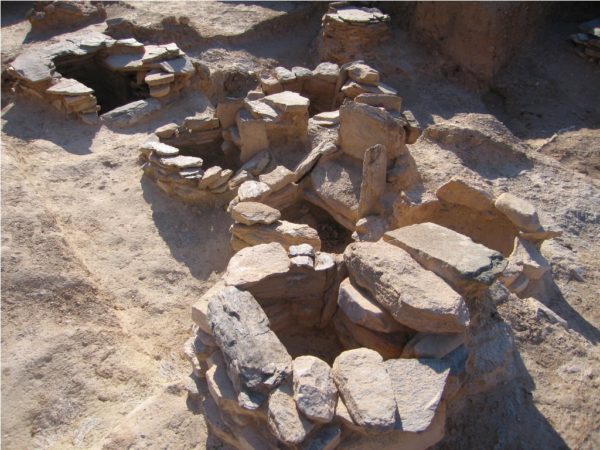
The configuration of the settlement is centralized. Most buildings are spreading to the top organized in building islets. The islets are separated from each other by narrow and often stepped streets that are generally parallel and perpendicular to the wall. The buildings of the islets are not separated by double walls except for a few exceptions, while this is the rule in other larger Cycladic settlements, such as Scarcos of Ios. The few independent buildings, all of which are elongated, are attached to the northern wall along their long axis. An exception is the peculiar small space 20 situated alone in the middle of the road.
The buildings themselves consist of one or two rooms of rectangular or trapezoidal shape and usually rounded corners. The two rooms usually form an angle between them and are rarely aligned along the same axis. The way of building is like that of the fortification, but the main building material is small and thin marble slabs.
The buildings either had their own, or shared with others, courtyards enclosed with a built-in fence wall. Built-in fireplaces were found in spaces 4, 11 and 22. The fireplaces in Kastri consist of two vertically positioned slabs which in some cases have between them another horizontal one that served as the base of the fireplace.
The movable finds show that the settlement of Kastri was full of life. The fragments of large pithos (clay barrels)found inside buildings echo organization for the storage of goods. The ceramic, stone-carving, miniature and metalwork arts seem to have been well developed.
The fine ceramics include jugs with bilk-like mouths for pouring out water, goblets with two handles, bell-shaped cups, conical cups with leaf or matte prints on their base, goat sacks and spherical compasses. The coarse clay items contain many types of pithos with tufted relief decoration, amphorae, basin-shaped hearths cradled in the ground as well as circular portable hearths. In addition to ceramics, clay objects were found among which several spindles.
About stone vessels, utensils and tools, there were several marble bottles, rectangular panels, ellipsoid grinders and various types of scrapers. Core parts, blade pieces, and obsidian processing waste were also found.
There are powerful finds related to metalwork practicing in the settlement. Several metal objects were found in Kastri. Such is the impressive find of a silver diadem with a stunning embossed decoration that depicts human forms and animal figures. Of interest are also some bronze objects, such as double axes and a spear tip. More important, however, is the finding of clay funnels for the melting of metals that retain inside them copper or lead rust, as well as schistolith (double-sided) and clay molds for the manufacture of tools and weapons.
It has even been assumed that building 11 was a metal workshop. Around the fireplace, slags mixed with coal and burnt fragments of vases were uncovered. An assembly of bronze objects (chisels, hole punchers, pins, and saw parts) was found in a corner on the floor in front of the fireplace. At the same spot, there were found miniature cone-shaped punchers and obsidian blades on one of which there was pasted metal residue. Along with the tools, one of the four clay funnels of the settlement was found here.
Finally, information on the inhabitants’ dietary habits is gathered from the organic residues. There were plenty of goat bones and sea shells.
The relations Kastri seems to have had with Asia Minor in terms of material culture have been particularly discussed. Certain types of ceramics found in Kastri, such as the two-handle goblet and the bell-shaped cup, find their parallel on the eastern side of the Aegean (Rutter 1979). It has been proved by laboratory analysis that the copper of several objects from Kastri, the Northeast Aegean islands and Asia Minor sites is similar in composition (Davis 1987, 727, 754). Recently, in the Liman Tepe (Klazomenes), a massive 60-ha settlement of the Kastri type was found (Erkanal 1997). More generally, Kastri’s period is a period of intensification in the relations between the Cyclades and other regions, such as Evia, the islands and the coasts of the eastern Aegean.
Source: Syros, Chalandriani-Kastri. From the research and the protection to the recovery of the archaeological site. Marisa Marthari.
Ed. Ministry of Aegean, 11thEphorate of Antiquities–Cultural Ministry
Translated by Constantine Hatziadoniu
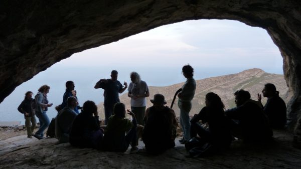
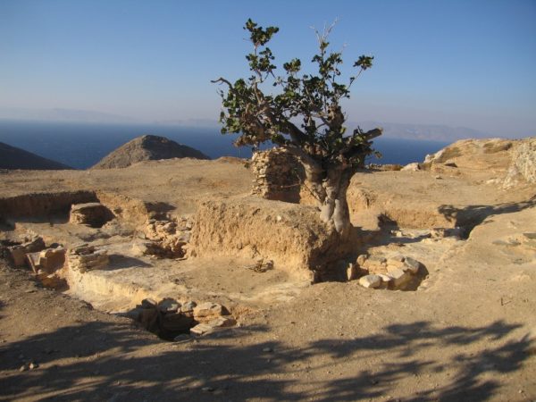
Pherecydes Cave
24 August 2016
Pherecydes the Syriot
Excerpts from the book by Evangelos N. Roussos, about the philosopher Pherecydes who was born in Syros in the 6th century BC.
“The tradition of heliotrope in Syros as a work of Pherecydes must be based on the description of Homer Syris (Syros) in Odyssey, which is located
Above of Ortyia (Delos), in the turn of the Sun
Here the zeal of some to bestow Pythagoras’ teacher with titles of discoveries and inventions, in the spirit of his time, was facilitated by a misinterpretation: the geographical definition of the position of the island to the west from Delos, higher, where the sun turns, was confused with the construction of the sun dial (heliotrope, from helio=sun and trope=turn) which is, of course, attributed to a contemporary of Pherecydes, a pioneer of science, the philosopher Anaximandros, testimonies 1.2 and 4. But also the Syriot theologian himself keeps the illusion that he goes along with his revolutionary era when, by imitating the map of Anaximandros, who first dared to put the world on a board, testimony 6, presents the god of the sky to create the veil of the earth and to draw upon it the stories and seas (see 20.2) “page 93, 9.1.”
On page 95 of the book Pherecydes the Syriot, E.N. Roussos reports that in the ancient sources there is no evidence of Pherecydes caves, as opposed to the local tradition that speaks of two caves of the philosopher in Syros, one in the Alithini and one in Richopo, where there are traces of ancient habitation.
Translated by Constantine Hatziadoniu
Relevant videos:
Useful link: https://www.arxaiologikoktimatologio.gov.gr/
Below you will find in greek the Bulletin of the Government Gazette (FEK) concerning the:
a) Declaration of archaeological sites: Kastri – Halandriani – Atsiganokastro – Delfinonissi – Chodra in Syros.
b) Determination of protection zones for archaeological sites A-B of Syros: