UCZ Government Gazette – UCZ of Syros (You can download it here)
SYROS: Urban Control Zones (UCZ)
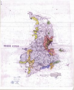
Urban Zones in Siros: with yellow color are the RCZ and with green the Archaeological sites
The Urban Control Zones (UCZ) defined by the 1337/83 law, article 29, paragraph 2 (Gov.Gzt. 33/Art/83), are areas of ecological protection, determined according to law 165/1986 (Art 160) “For the protection of the environment” and are aiming at the “immediate protection and control of the constructions and land use for areas outside the urban planning, in order to prevent environmental degradation and uncontrolled development by the creation of real situations that undermine rational planning”.It was used as a leverage for legislating the proposals of the Special Spatial Planning Studies (SSPS), and they are approved with a Presidential Order.
The SSPS is a procedure for the rational planning of a sensitive and problematic area, aiming at the development while protecting the natural resources and the natural and anthropogenic environment, in the context of a sustainable development.
All the data of the natural and anthropogenic environment are examined for the area under study, and then recommendations are made regarding any building restrictions, land uses, siting of production activities, and technical infrastructure operations and projects, by defining and demarcating zones of environmental protection.
These studies are kept in the Archives of the Directorate for Spatial Policy and in the libraries of the Ministry and of the Technical Chamber of Greece.
Source: Ministry of Environment & Energy
In “Apano Meria” the following areas have been classified as RCZ:
2c. The border of this area starts from the coast outside and north of the Trahilos cape, and extends to the top of the Delphini hill. From there goes south, parallel to the shore and in a distance of 500 meters from it, until it reaches the north limits of the village of Kini, and from there to the west, following the coastline.
2d. The border of this area starts opposite of Vambarousa islet, up to the top of the Delfini hill, and then extends towards the south, parallel to the shore and in a distance of 500m from it, until the north stream that ends up at the Aetos bay.
2e. The border of this area starts from the cove south of the Lia bay, perpendicular to the shore. It continues uphill to the mountain, and from there extends towards the north, parallel of the shore and in 500m from it, until it reaches the Three Lagoons of Grammata bay, and ends to the shore of the middle lagoon.
3a. The border of this area starts from the shore at the middle lagoon of the Grammata bay, extends northeast and turns to the west, parallel to the shore, and in 250m from it, ends to the sea perpendicular to the shore at the cliff of Grammata.
Translated by Nikos Vakondios / Edited by Constantine Hatziadoniu